
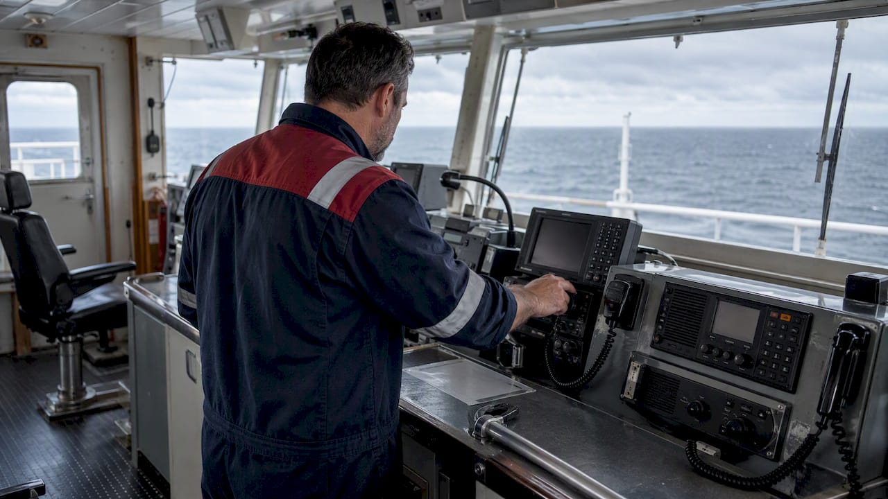
GMDSS divides the world’s oceans into four sea areas, A1 through A4, and which area or areas your vessel operates in determines the radio and distress equipment you must carry under SOLAS. Since recent updates, A3 and A4 are no longer fixed geography alone: they depend on the satellite service actually installed on your ship.
Özetle:
- Installing a recognized global mobile satellite service can eliminate the vessel’s A4 coverage gap, making it possible to operate without polar-region-specific equipment.
- Equipping for A3 coverage now depends on the specific satellite hardware installed, requiring vessel-specific verification rather than fixed geography.
- A vessel’s CERTIFICATE of GMDSS compliance must match its actual operational areas, necessitating equipment upgrades before changing routes into higher sea areas.
- Proper record-keeping of regular DSC tests, power checks, and equipment maintenance is critical to passing port inspections and maintaining compliance.
- Boundary zones between sea areas are often fuzzy, so operators should prepare for weaker coverage near official limits, particularly during seasonal or atmospheric changes.
İçindekiler
- Sea areas A1 through A4: definitions, ranges, and what they mean for you
- Equipment requirements by sea area: a SOLAS-mapped checklist
- Compliance actions: SOLAS rules, certification, and logbook discipline
- Testing, maintenance, and satellite choices that shape your sea-area status
- How to confirm which sea areas apply to your voyage
- Who coordinates search and rescue across sea areas
- Why sea area classification matters for vessel certification
- Emergency protocols differ by area, not just by equipment
- How sea area designation affects insurance requirements and costs
- Operating near sea area boundaries brings its own challenges
- International harmonization: how sea area rules stay consistent
- Where VesselFlag fits in your GMDSS compliance picture
- Getting your MMSI and registration paperwork sorted
- Kaynaklar
- SSS
Sea areas A1 through A4: definitions, ranges, and what they mean for you
Sea Area A1 is the zone within continuous VHF digital selective calling coverage of a coast station, typically extending 20 to 30 nautical miles from shore. If your route stays inside that band, VHF DSC alone can meet your primary distress alerting obligation.
Sea Area A2 picks up where A1 coverage ends, defined by continuous MF DSC coverage that reaches approximately 100 nautical miles offshore, excluding A1 waters. National authorities set the actual boundaries, so the same stretch of coastline can have different A2 limits depending on which government declared it.
Sea Area A3 covers the reach of an IMO-recognized mobile satellite service, which in practice means most of the world’s oceans outside polar latitudes. This is the area where the 2024-era shift matters most: A3 and A4 status now depends on the specific satellite equipment installed aboard your vessel, not just a chart.
Sea Area A4 is everything outside A1, A2, and A3, historically the polar regions beyond geostationary satellite reach. A vessel fitted with a global recognized mobile satellite service can eliminate its own personal A4 exposure entirely, because continuous coverage from that service removes the gap the A4 designation was intended to cover.
- A1: VHF DSC range, about 20 to 30 nautical miles from a coast station.
- A2: MF DSC range, about 100 nautical miles, with boundaries set nationally.
- A3: Coverage of a recognized mobile satellite service, ship-dependent since recent SOLAS updates.
- A4: Everything beyond A1 through A3, reducible through global satellite fitment.
Equipment requirements by sea area: a SOLAS-mapped checklist
Every GMDSS-regulated ship carries a baseline regardless of where it sails: an EPIRB, a DSC-equipped VHF radio, a search and rescue transponder, and NAVTEX or an Inmarsat-C receiver for maritime safety information where NAVTEX coverage does not reach. From there, carriage requirements stack according to the areas the ship actually transits, not its tonnage or type.
- A1 only: VHF DSC with continuous watchkeeping on channel 70, plus the baseline EPIRB, SART, and NAVTEX.
- A1 + A2: add MF DSC on 2187.5 kHz, with an MF radiotelephone for voice communication.
- A1 + A2 + A3: add an Inmarsat or equivalent recognized mobile satellite ship earth station, or HF DSC as an alternative.
- A4 exposure: add HF DSC and HF radiotelephone unless a global satellite service already removes that exposure.
HF remains the fallback where satellite coverage is thin or unavailable, since HF sky-wave propagation can carry ship-to-shore distress traffic thousands of miles using designated distress and safety frequencies. NAVTEX reception needs to be checked against your actual route, since coverage gaps exist even within nominal A1 and A2 zones, and continuous watch obligations apply to whichever systems your area combination requires, not just the ones installed.
Profesyonel İpucu: Match your watchkeeping schedule to your highest sea area, not your lowest, since inspectors check against the most demanding leg of your declared route.
Compliance actions: SOLAS rules, certification, and logbook discipline
SOLAS Chapter IV sets the governing principle: carriage follows the sea area or areas a ship operates in, and flag states enforce that mapping through survey and certification. A vessel certified for A1 through A3 that later sails into A4 waters without the right HF or satellite fit is out of compliance the moment it crosses that line, regardless of what its certificate said when issued.
GMDSS radio operator certification requires documented sea service aboard fully GMDSS-equipped ships plus approved course completion, and revalidation depends on either further sea service or a refresher course within the certificate’s validity window. Our SOLAS overview for yacht owners covers how these carriage rules intersect with survey requirements more broadly.
Radio logbooks need to show more than “equipment tested.” Expect port state control to look for:
- Dated records of weekly and monthly DSC test calls, including named stations contacted.
- Battery and backup power checks with results, not just a checkmark.
- Any equipment failure, repair, or downtime period, logged as it happens.
- Distress, urgent, and safety communications with full detail, retained per flag-state rules.
Administrative gaps, especially incomplete logbook entries and missing test records, are cited by inspectors more often than outright missing equipment. Our maritime documentation checklist walks through the record keeping habits that keep a vessel audit-ready.
Testing, maintenance, and satellite choices that shape your sea-area status
A disciplined test schedule protects you at inspection and at sea. Weekly DSC test calls, monthly full-system checks, and logged station contacts turn “we tested it” into evidence an inspector can verify in seconds.
Battery and UPS checks deserve the same rigor: record voltage readings, note replacement dates, and log the actual station contacted during each test rather than a generic “test passed” entry. Inspectors increasingly expect that level of detail, since a vague log entry reads the same as no entry at all.
Choosing a global recognized mobile satellite service, an Iridium-class system rather than a regionally limited one, can remove your vessel’s personal A4 exposure by providing continuous alerting coverage everywhere you sail. That single equipment decision can simplify your carriage obligations and your logbook at the same time. HF should stay aboard as mandatory redundancy on any vessel that ventures into A3 or A4 waters, since satellite systems can fail and HF remains the only method that does not depend on a single provider’s network.
Profesyonel İpucu: Log every test with the station name and time, not just a pass or fail, since that detail is what separates a clean inspection from a flagged deficiency.
How to confirm which sea areas apply to your voyage
Route planning starts with the IMO GMDSS Master Plan and GISIS database, which list shore-based services and NAVAREA or METAREA boundaries for maritime safety information broadcasts. Cross-reference those with your installed satellite provider’s own coverage declaration, since a recognized mobile satellite service’s published footprint is what actually defines your A3 exposure now, not just the chart.
National declarations matter too. The United States, for instance, has declared specific A1 zones based on Rescue 21 VHF coverage, and other flag and coastal states publish their own A1/A2 extents.
- Check the GMDSS Master Plan and GISIS for shore service coverage along your route.
- Compare your satellite provider’s declared footprint against your installed equipment.
- Review national declarations for the waters you will transit.
- When boundaries are unclear, equip and certify for the more demanding area and document that decision.
Who coordinates search and rescue across sea areas
Search and rescue coordination follows the NAVAREA and rescue coordination center structure that underlies GMDSS itself, not the sea area designation directly. Each NAVAREA has a coordinating country responsible for broadcasting maritime safety information and relaying distress alerts to the appropriate rescue coordination center, and that structure functions the same whether a vessel is in A1 coastal waters or A4 open ocean.
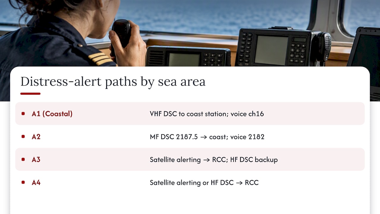
What changes by sea area is how a distress alert reaches that coordination network in the first place. In A1, a VHF DSC distress call goes straight to a coast station that alerts the nearest rescue coordination center almost immediately. In A2, MF DSC performs the same function over a longer range. In A3 and A4, the alert typically routes through a satellite ground station before it reaches the coordinating authority, which can add a short delay compared to terrestrial VHF or MF alerting.
This is why equipment carriage and rescue coordination are really two sides of the same requirement. A vessel with the wrong equipment for its sea area is not just out of compliance on paper, it is also less likely to get a fast alert to the rescue coordination center that actually covers its position. Flag states and coastal authorities publish NAVAREA boundaries and coordination responsibilities through the same GMDSS Master Plan referenced for route planning, so checking that resource once covers both the equipment and the rescue-coordination question.
Why sea area classification matters for vessel certification
A vessel’s GMDSS sea area designation is not a side note on its safety certificate, it is one of the core facts a surveyor verifies before issuing or renewing it. The certificate states which areas the ship is approved to operate in, and that statement is directly tied to the equipment fit confirmed during survey.
This creates a practical constraint for owners planning new routes or trades. If your certificate covers A1 through A3 and a new charter or trading pattern takes the vessel into A4 waters, you cannot simply sail there: the equipment fit needs to change first, and the certificate needs to reflect that change before the flag state or a port state inspector will sign off. Certification, in this sense, is less a one-time event than an ongoing match between where a ship actually goes and what its paperwork says it is equipped for.
Flag states carry the enforcement responsibility here, since SOLAS delegates survey and certification to them rather than to a single global body. That is one reason the choice of flag matters beyond tax or cost considerations: some administrations run tighter GMDSS survey processes than others, and a vessel’s compliance history under one flag does not automatically transfer if ownership or registration changes. Owners moving a vessel between registries need to confirm that sea area certification carries over cleanly, or gets reissued promptly under the new flag.
Emergency protocols differ by area, not just by equipment
The mechanics of a distress alert change meaningfully as you move from A1 to A4, even though the underlying obligation (get help fast) stays the same. In A1, a DSC distress call on VHF channel 70 reaches a coast station within line of sight almost instantly, and voice follow-up happens on channel 16. That immediacy is why A1 equipment requirements are the lightest of the four areas: the terrestrial infrastructure does most of the work.
In A2, the same DSC-then-voice sequence happens on MF frequencies instead, with 2187.5 kHz carrying the distress alert and 2182 kHz handling voice traffic. The longer range comes with a tradeoff: MF propagation is more sensitive to atmospheric conditions than VHF, so redundancy checks matter more here than in coastal A1 work.
A3 and A4 shift the protocol to satellite alerting, typically through an Inmarsat or equivalent terminal, with HF DSC as the backup path where satellite coverage is marginal or the terminal has failed. The practical difference for crews is procedural: satellite distress alerting usually involves a short registration and routing step before the alert reaches a rescue coordination center, compared to the near-instant terrestrial handoff in A1 and A2. Crew drills should reflect whichever protocol matches the vessel’s actual certified area, since muscle memory built on VHF procedure does not transfer cleanly to satellite alerting under pressure.
How sea area designation affects insurance requirements and costs
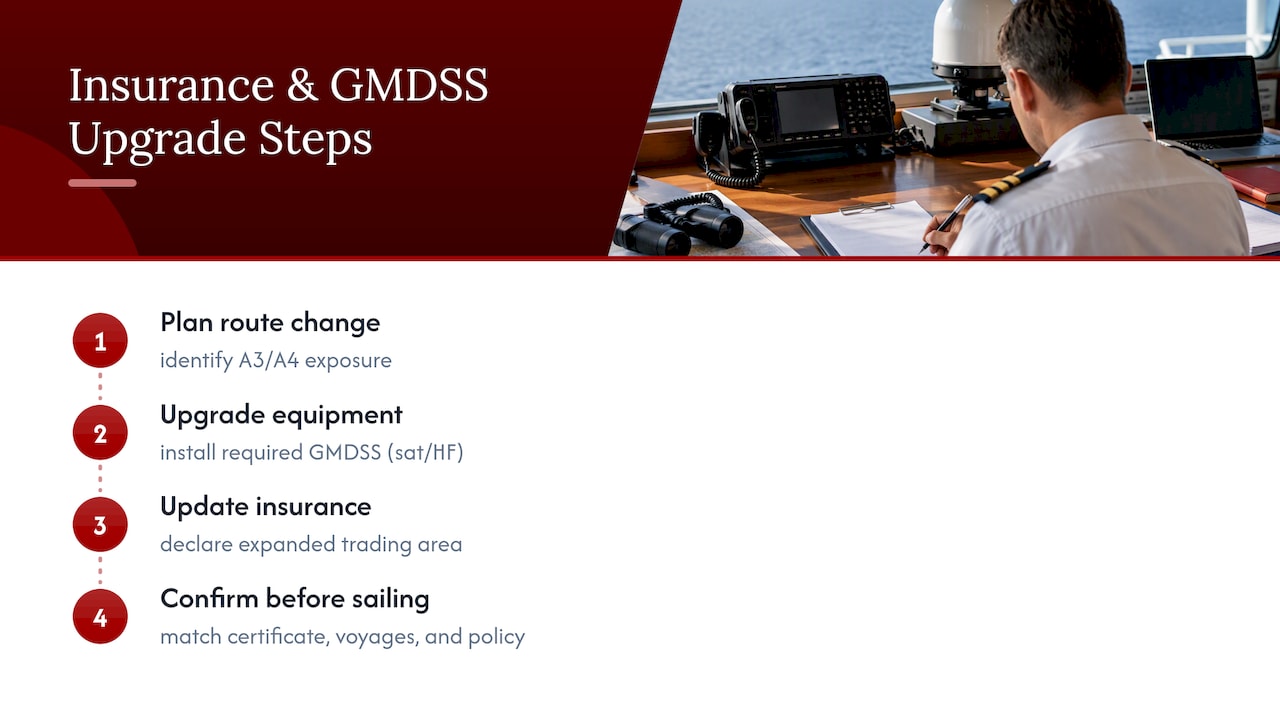
Marine insurers generally price and structure hull, machinery, and liability cover around a vessel’s declared trading area, and GMDSS sea area certification is one of the documents underwriters check to confirm that declaration matches reality. A vessel certified and equipped only for A1 and A2 coastal work that then operates in A3 or A4 waters without the corresponding equipment upgrade risks more than a compliance citation: it can create a coverage gap if an insurer later argues the vessel was operating outside its declared and certified trading area.
This is less about a fixed premium formula and more about alignment. Underwriters want the vessel’s certificate, its actual voyages, and its insurance declaration to tell the same story. A well-documented equipment upgrade, from A2-only MF DSC to a full A3 satellite and HF fit, supports a clean expansion of a vessel’s insured trading area. A mismatch between what the certificate says and where the vessel actually sails is the kind of detail that surfaces during a claims investigation, often at the worst possible time.
Owners planning a change in trading pattern, a new charter route into open ocean or polar-adjacent waters, for instance, do well to treat the GMDSS equipment upgrade and the insurance declaration update as a single project rather than two separate errands. Confirming both before the new route starts avoids the situation where a vessel is technically compliant on paper but under-covered in practice, or compliant and covered but flagged at the next survey for a certificate that no longer matches its voyage history.
Operating near sea area boundaries brings its own challenges
Boundaries between A1 and A2, or between A2 and A3, are rarely a hard line on the water. Coastal VHF coverage fades gradually rather than stopping at a precise mile marker, and a vessel near the nominal edge of A1 can find itself with marginal DSC reception well before charts suggest it should. The same applies moving from A2 into A3, where MF coverage from shore stations and satellite footprint edges can both be weaker than the nominal range figures suggest, particularly in areas with limited coast station infrastructure.
This matters most for vessels that routinely operate near a boundary rather than clearly inside one area or another. A fishing vessel or a coastal trader that spends significant time at the edge of declared A2 coverage faces a practical choice: equip conservatively for the higher area it occasionally brushes against, or accept the operational risk of reduced coverage during that boundary time. Most experienced operators choose the former, since the cost of carrying one extra piece of equipment is far lower than the cost of a missed distress alert during a boundary crossing.
Seasonal and atmospheric variation adds another layer. MF and HF propagation shift with time of day and season, so a route that sits comfortably within A2 coverage during daylight can see degraded reception at night. Crews operating near boundaries benefit from treating the nominal range figures as a guide rather than a guarantee, and logging actual reception quality during voyages helps build a realistic picture of where coverage genuinely holds up.
International harmonization: how sea area rules stay consistent
GMDSS sea area definitions are set through IMO resolutions and criteria, most directly through the technical criteria for establishing A1 and A2 coverage, which give governments a common method for measuring field strength and calculating coverage radii. That shared technical basis is what allows a ship certified under one flag to have its sea area status recognized consistently when it calls at a port under another administration’s jurisdiction.
Enforcement, though, stays national. Each government declares its own A1 and A2 zones based on its coast station network, submits those declarations for inclusion in the GMDSS Master Plan, and its own maritime authority or delegated classification society handles survey and certification against the IMO criteria. Port state control then checks a visiting vessel’s certificate and equipment against the sea areas it is documented to operate in, using the same IMO-based framework regardless of which flag issued the original certificate.
The result is a system that looks uniform on paper, built on one set of IMO criteria, but varies in practice depending on how thoroughly a given flag state surveys and enforces it. That variation is one reason the choice of registry carries real weight for GMDSS compliance, not just for tax or operating cost reasons. A flag administration with a rigorous, well-documented survey process makes it easier to maintain a clean compliance record as sea area exposure changes over a vessel’s operating life.
Where VesselFlag fits in your GMDSS compliance picture
Correct MMSI assignment and ship station licensing are administrative details that show up repeatedly in port state control findings when they are wrong or missing, often alongside the logbook gaps inspectors already look for. Getting that paperwork right the first time removes one recurring source of deficiency.
VesselFlag handles MMSI radio licensing, flag registration, and the ship station documentation that ties into a vessel’s GMDSS certification. Shipboard equipment testing, watchkeeping, and operator certification remain the owner’s and crew’s responsibility: our role is getting the paperwork behind your station license and registration correct and current.
— VesselFlag
Getting your MMSI and registration paperwork sorted
Sorting out MMSI licensing and flag registration alongside your GMDSS equipment plan means one less administrative gap for a port state inspector to find. Specialized services handle MMSI radio license applications, flag registration across multiple jurisdictions, and the documentation packages that tie a vessel’s station license to its registration paperwork.
Before reaching out, have your ship’s particulars, intended trading routes, and current equipment list ready, since those details determine which registry and licensing path fits your vessel.
| What you need | Why it matters |
|---|---|
| Ship particulars (name, tonnage, build year) | Required for both registration and MMSI application |
| Planned trading routes | Determines sea area exposure and equipment fit |
| Current GMDSS equipment list | Confirms what’s already installed before licensing |
| Preferred flag jurisdiction | Sets timeline and documentation requirements |
For a vessel needing UK station licensing, our Birleşik Krallık Bölüm 1 Yat Kaydı page covers registration alongside UK Part 1 MMSI (OFCOM) registration, and our broader flag registration services list options across San Marino, Malta, Poland, and other jurisdictions for owners comparing paths.
Kaynaklar
For sea area boundaries and equipment criteria, consult the USCG Navcen GMDSS pages, the AMSA GMDSS handbook, and IMO resolution MSC.509(105). Always check your flag state’s own notices for nation-specific A1/A2 designations, since these vary by coastal infrastructure. For SOLAS documentation obligations beyond radio equipment, Worldwide Express covers SOLAS shipping compliance from a logistics standpoint, and Firehouse Freight explains marine equipment shipping logistics for owners sourcing or replacing GMDSS hardware.
SSS
What are the SOLAS requirements for the GMDSS?
SOLAS Chapter IV requires ships to carry radio equipment matched to the sea area or areas they operate in, rather than a fixed list based on vessel size or type. The specific equipment required for each area, from VHF DSC in A1 through satellite or HF systems in A3 and A4, is verified at survey and reflected on the vessel’s safety certificate.
Is GMDSS mandatory for all ships?
GMDSS carriage requirements apply to SOLAS-regulated ships, generally those on international voyages above the SOLAS convention’s size threshold, rather than to every vessel afloat. Smaller craft and many recreational vessels fall outside SOLAS and follow national radio carriage rules instead, which vary by flag and cruising area.
How do I know which GMDSS sea area my route falls into?
Check the IMO GMDSS Master Plan and your flag or coastal state’s published A1 and A2 declarations, then compare those against your installed satellite provider’s coverage footprint for A3 exposure. When a route crosses a boundary or the coverage is unclear, equipping for the more demanding area and documenting that choice is the safer approach.
What must a GMDSS radio logbook record?
A GMDSS radio logbook should record distress, urgent, and safety communications, routine DSC test calls with named stations contacted, and battery or backup power checks with results. Retention periods and exact content rules are set by national instruments, so checking your flag state’s specific requirement matters alongside the general practice.
Can installing satellite equipment change my vessel’s sea area classification?
Yes, installing a global recognized mobile satellite service can remove a vessel’s personal A4 exposure, since continuous coverage from that service closes the gap the A4 designation exists to cover. This shift makes equipment procurement a direct lever for simplifying a vessel’s carriage obligations rather than a separate compliance step.